Myth #1: The proposed trail will be a “Multi-Use Trail”.
Facts: The trail, as proposed by Parks & Recreation Staff, is being termed a “Multi-Use Trail” (MUT), or more recently as an “East Multi-Use Trail” (EMUT), meaning that the trail is being designed for use by pedestrians, equestrians and bicyclists.
While such a designation is technically correct in that none of these types will be prohibited from using the trail, in fact, neither pedestrians nor equestrians are likely to make much use of it. There will be no staging area for equestrians at the southern end of the trail at Golf Club Drive, and there is also very limited parking available at that location. Furthermore, the primary users of the trail are likely to be bicyclists. Pedestrians—most of whom don't enjoy sharing a single-track trail with bicyclists—will tend to avoid it.
In addition, the main proponents are mountain bikers, who have been working with Parks and Recreation Staff in its design, and have been actively raising funds to help with both its design and contruction. Members of this group have said “It will be nice for us to have the opportunity to design and build our own trail.”
Hence the proposed trail should really be called a Mountain-Biking Trail (an MBT) and not a Multi-Use Trail.
Question: Does the recent addition of the word “East” imply that in the future there is to be a “West Multi-Use Trail”?
At the meeting of the Parks and Recreation Commission on July 27, 2010, where the proposed trail was first discussed, mountain-bikers expressed their desire to open both the Spring Trail and the Brayshaw Trail to bicyclists. This desire was reinforced by a map, prominently displayed on the MBoSC website. Although this map was subsequently removed, the desire may still exist, in spite of current words to the contrary. The Spring Trail does indeed parallel the western boundary of the Pogonip.
Myth #2: An opportunity is needed for mountain bikers to have access to an area in “close proximity to urban areas…within the City limits”.
Facts: This myth, which appears on Page 3 of the Revised Mitigated Negative Declaration, is unsupported by any data.
In fact, several areas available for mountain biking lie in close proximity to our urbanized area.
De Laveaga Park, an area of some 565 acres with approximately 8.7 miles of mainly single-track trails open to mountain bikers, lies entirely within the City limits. Here is a map of the trails.
The upper video shows a pair of mountain bikers riding down one of the trails. The trails in De Laveaga are termed “multi-use” by our Parks Department, but this video shows no hikers on this trail.
Please install a Flash Plugin, with version 9.0.115 or greater.
There are also extensive opportunities for mountain biking on the upper part of the UCSC campus, which is adjacent to the city limits.
The fire roads on the upper campus have long provided opportunities for easy mountain biking. There are, in addition, a number of single-track trails that are not publicized.
This second video, which is the first 3.8 minutes of a 9-minute video, purports to have been shot on the UCSC campus. (It may take a while to load up in your browser.)
The videographer includes this caption:
“Exploring the secret mountain biking treasures of UC Santa Cruz. Rumored trail names are removed to protect the trails.”
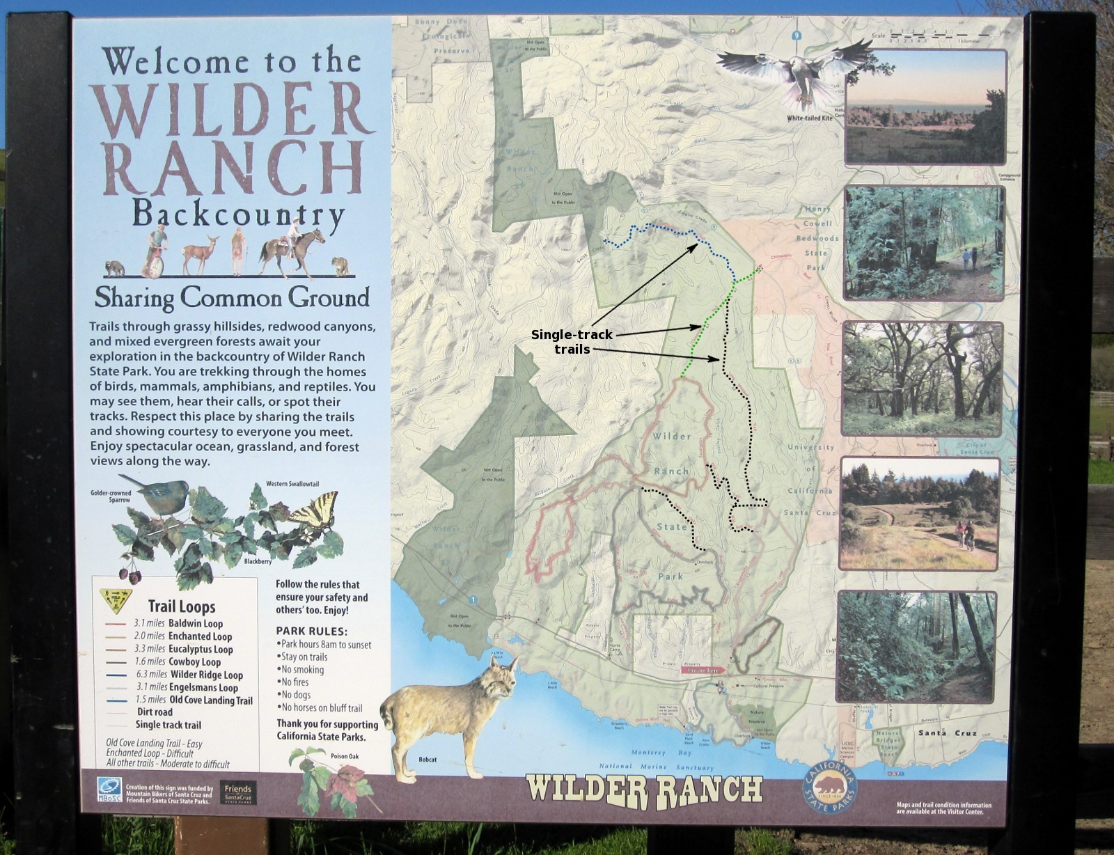
Finally, Wilder Ranch State Park, which is easily accessible from the urban area of Santa Cruz via a convenient 1.5-mile paved bike path, has many miles of single-track trails available for mountain biking.
Here is an image of a “Welcome” sign at the Wilder Ranch State Park that shows the network of trails (many of which are single-track—shown by dotted lines) that are accessible to mountain bikers. (Click on the image to enlarge it—if you can enlarge your browser window, do so.)
Myth #3: The proposed trail will drive out drug dealers and illegal campers.
| Year | 2008 | 2009 | 2010 (Jan) |
2010 (Feb-Dec) |
2011 | 2012 |
|---|---|---|---|---|---|---|
| Reports | 1 | 4 | 2 | 0 | 0 | 0 |
Facts: The drug dealing and illegal camping in the vicinity of Redwood Creek that caused concern in 2009 and 2010 has essentially disappeared, owing to concerted efforts by police, Parks staff and other community groups. Park rangers have told us that no citations have been issued in the area during the past two years. See also the table of police reports.
Moreover, it is unlikely that the presence of bicyclists or other trail users on the proposed trail will have much of an effect on any illegal activity that may occur in that area in the future. Drug activity has been increasingly occuring along the river levee where the river flows under Highway 1 and through Santa Cruz, where many people walk and bicycle along the levee path. The mere presence of such people, who are apt to be disinclined to interact with drug users or dealers, has had little effect.
Furthermore, the rail corridor has been, and to some extent still is, an area attractive to illegal activity. Drug dealers have parked along Highway 9 and climbed up to the rail corridor to provide their drugs to users who walk or cycle up the rail line from Harvey West Park. To limit such activity, our police have focused on this area, and this has proved to be effective.
In addition, many bicyclists currently (and illegally) cycle along the rail line on a daily basis, and this has had little effect on any drug dealing or use in that area.
Myth #4: The proposed trail will provide an alternate and attractive commute route to the UCSC campus, and thus could aid in reduction in motor vehicle use and consequent greenhouse gas emissions.
Facts: This myth, which appears on Page 57 of the Revised Mitigated Negative Declaration, is completely unsupported by any data. The proposed trail is not mentioned in the City's Bicycle Plan, nor is it mentioned in the City's Capital Improvement Program.
In fact, there are many options open for those who want to commute to UCSC using a bicycle, all of which are much shorter, require less of a climb, and are available at all hours of the day.
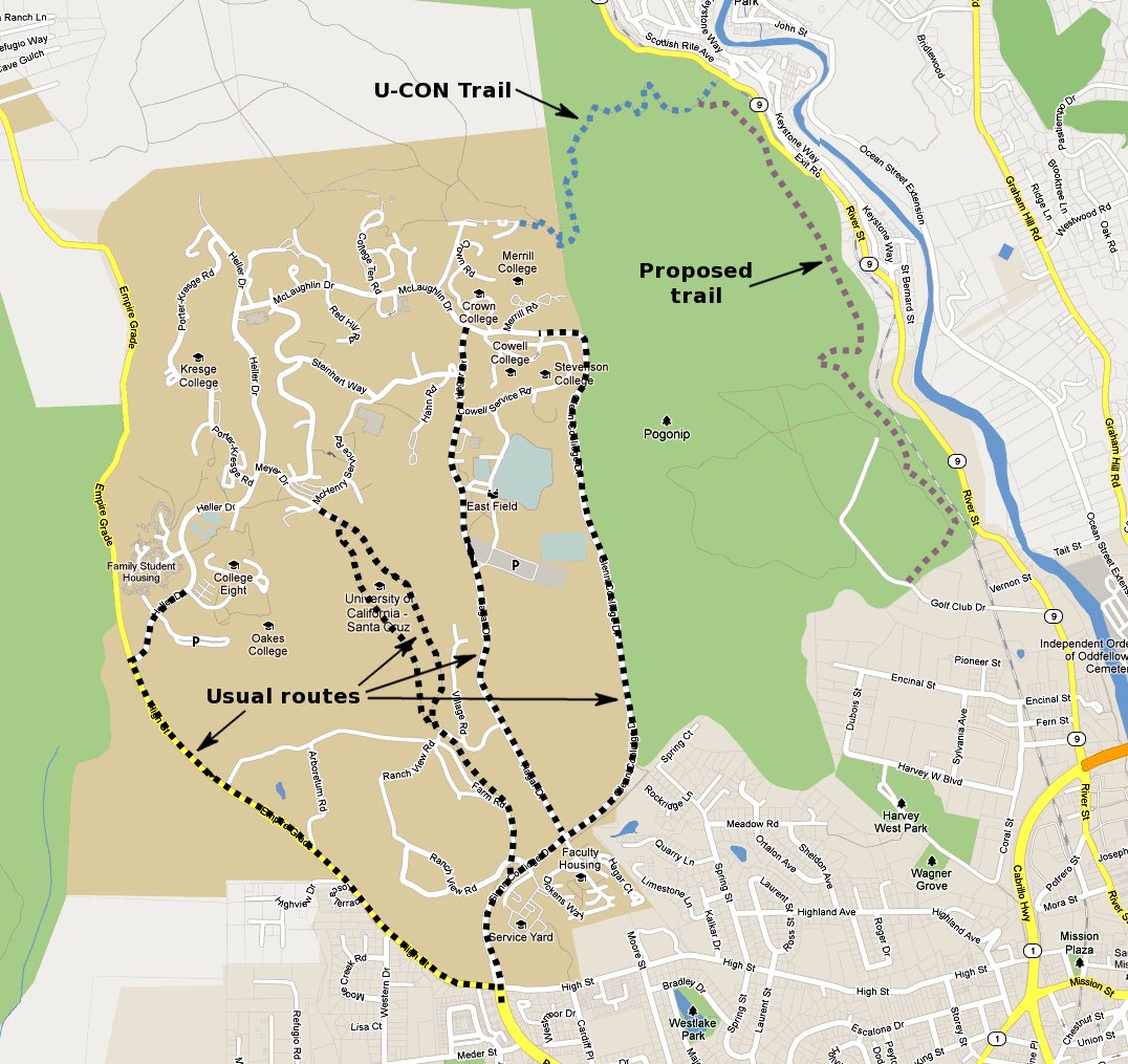
Here is a map that compares the current bicycle routes to the campus—now used by nearly a thousand bicyclists per day (official counts from 2011 estimate approximately 950)—with that of the proposed trail. (Click on the map to enlarge it.) The University Connector (U-CON) Trail, which would be accessible from the proposed trail, climbs to an elevation over 100 feet higher than the main library on campus.
Moreover, the route via the proposed trail and the U-CON Trail is longer than any of the currently used routes, and would increase the travel time by at least 50 percent compared with the usual routes.
Furthermore, Transit District buses, which leave Pacific Avenue every few minutes, have popular bike racks. The Campus Bike Shuttle, which departs from the CVS Store on Mission every 15 minutes throughout weekday mornings, is likewise popular. A second UCSC Bike Shuttle departs from Pacific Avenue and Cathcart on an hourly basis. The UCSC buses, which operate only on campus, also have bike racks available for those who do not wish to ride up the hill unassisted.
The notion that the proposed trail will actually reduce vehicle travel and greenhouse gas emissions is therefore something of a reach—one might even say nonsensical.
Myth #5: The alternative of a rail trail adjacent to the Big Trees Railroad tracks is not feasible.
Facts: This myth, which appears on Pages 12–14 of the Revised Mitigated Negative Declaration, is documented only by hearsay and assertion—no real analysis is provided.
In fact, a study prepared in 2006 for the County Public Works Department indicates that such a rail trail is feasible, especially for the southernmost 1.5-mile segment. The complete “San Lorenzo Valley Trail Feasibility Study”, which covers other options in addition to the rail line route, may be found here. Appendix E of the study relates to the rail line route, which is analyzed in detail for each of 21 quarter-mile segments.
We are concerned with the stretch north from Encinal Street in Harvey West Park to the southern end of the 1942 trestle just south of the crossing of the rail line by Highway 9. This stretch is covered by segments 2 through 9 of the study. We have extracted the detailed analysis from Appendix E for these segments (which includes many photographs), thus creating a document that may be found here.
This alternate rail trail route has several advantages over the proposed route. It connects well with the U-CON Trail at the northern end, and so provides equally good access to the upper UCSC campus and Wilder Ranch State Park. At the southern end it would naturally start from Encinal Street in Harvey West Park, which allows better parking and connects better to the levee path than does Golf Club Drive. It would also likely attract a broader class of users—road bikes and families in addition to mountain bikers. A path along the rail line would be scenic. Families could ride up to Rincon and the good swimming holes on the San Lorenzo River and Henry Cowell State Park.
Moreover, this alternative could be the initial segment (approximately 30 percent) of a rail trail all the way to Felton—by far the preferred alternative for bicyclists among the options considered in the 2006 study. At the time of the study, Big Trees Railroad was receptive to the idea. Although this was for a path all the way to Felton, there is a possibility that Big Trees would also be open to this shorter segment.
We recognize that the rail trail alternative would be more costly than the proposed trail through the Pogonip. The trail design, as proposed by Ifland Engineers, is to very high standards, with structures that facilitate the path at railroad trestles and steep cliffs. However, in this initial segment, there is only one railroad bridge—that over Golf Club Drive—that is too narrow for a path next to the tracks. That bridge would need structural modification. (This pinch point could be avoided if the southern entrance, perhaps initially, were to be at Vernon Street.) The high standards chosen by Ifland Engineers may be excessive, and likely could be lowered so as to reduce significantly the estimated cost. There is good political support from the county for the construction of such a rail trail.
There is currently an ad hoc path, on the east side of the tracks, that is used by many bicyclists (estimated at approximately 50 per day), but its use is both hazardous and illegal. The 2006 Study's engineering design recommends that the path be on the west side of the tracks, which would be much safer, and would relieve Big Trees Railroad of liability issues.
Unfortunately City staff have as yet shown no interest in pursuing the rail trail alternative, noting that the route does not lie totally within the city limits, would require working with both the County and Big Trees Railroad, and would be too costly.
It is our opinion that this alternative should not be dismissed out of hand, but that there should be at least some exploratory discussion among the relevant parties regarding it. We have yet to see any evidence for such discussions.